YOUR NEXT DISCOVERY/SpaceFollow your curiosity
Topography Between Mars Helicopter and Rover for Flight 17
NASA / JPL · Reuse terms

Space / 2021-12-07

Topography Between Mars Helicopter and Rover for Flight 17

Topography Between Mars Helicopter and Rover for Flight 17

NASA's image library records Topography Between Mars Helicopter and Rover for Flight 17.

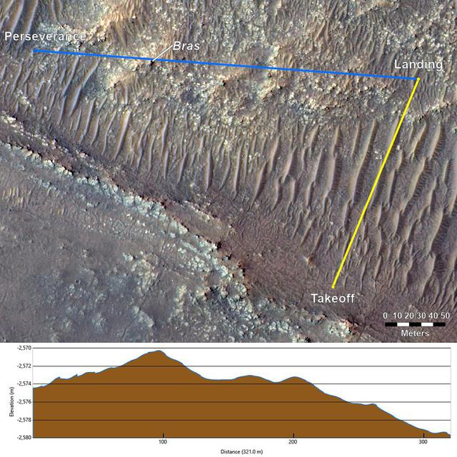
This annotated image from NASA's Mars Reconnaissance Orbiter (MRO), and the topographic map below it, provide a look at the altitude of surface features standing between the agency's Perseverance Mars rover and Ingenuity helicopter at the conclusion of the rotorcraft's 17th flight at Mars on Dec. 5, 2021. In the image of the surface – taken by MRO'

SERENDIPITYA little unexpected
FamiliarWeird

This annotated image from NASA's Mars Reconnaissance Orbiter (MRO), and the topographic map below it, provide a look at the altitude of surface features standing between the agency's Perseverance Mars rover and Ingenuity helicopter at the conclusion of the rotorcraft's 17th flight at Mars on Dec. 5, 2021. In the image of the surface – taken by MRO's High Resolution Science Experiment (HiRISE) camera – Ingenuity's flight path is depicted in yellow. Perseverance's location is indicated in the upper left, with the blue line delineating its line of sight to the helicopter's landing spot. The location of the tallest point on Mars' surface between rover and helicopter during its final descent is the hill near the center of image that the Perseverance science team has nicknamed "Bras," after a ci

Explore NASA's original image record for credits and available downloads.

NASA Image and Video LibraryTopography Between Mars Helicopter and Rover for Flight 17

Original explanation based on the sources above. Images carry their own reuse terms.